


|
|
| Radar/Satellite images courtesy of NOAA/NWS and Weather Underground. | |
|
METRIC |
IMPERIAL
|
Updated: 03-Aug-2026 @ 3:00am | |||||||||||||||||||||||||||||||||||||||||||||||||||||||||||||||||||||
| Temperature | Current Conditions | Forecast / Storm Prediction | ||||||||||||||||||||||||||||||||||||||||||||||||||||||||||||||||||||
|
|
|
||||||||||||||||||||||||||||||||||||||||||||||||||||||||||||||||||||
| Dew Point | Liquid Precipitation | Wind Speed | Sun/Moon | |||||||||||||||||||||||||||||||||||||||||||||||||||||||||||||||||||
|
|
|
|
|||||||||||||||||||||||||||||||||||||||||||||||||||||||||||||||||||
| Humidity | Barometer | |||||||||||||||||||||||||||||||||||||||||||||||||||||||||||||||||||||
|
|
|||||||||||||||||||||||||||||||||||||||||||||||||||||||||||||||||||||
| Heating Degree Days | Coming Soon | Wind Chill | Air | |||||||||||||||||||||||||||||||||||||||||||||||||||||||||||||||||||
|
|
|
|
|||||||||||||||||||||||||||||||||||||||||||||||||||||||||||||||||||
| UV Summary/Forecast | Solar Summary | |||||||||||||||||||||||||||||||||||||||||||||||||||||||||||||||||||||
|
|
|||||||||||||||||||||||||||||||||||||||||||||||||||||||||||||||||||||
| Almanac | Station All Time Records | Cloud Level | ||||||||||||||||||||||||||||||||||||||||||||||||||||||||||||||||||||
|
|
|
|
|||||||||||||||||||||||||||||||||||||||||||||||||||||||||||||||||||
|
METRIC |
IMPERIAL
|
Updated: 03-Aug-2026 @ 3:00am | |||||||||||||||||||||||||||||||||||||||||||||||||||||||||||||||||||||


| 1 Rain season: Jan 1st to Dec 31st. 2 Snow season July 1st to June 30th. 3 Snow manually measured usually around 7AM and 7PM. 6 Air Quality Index is provided by Minnesota Polution Control Agency and is updated hourly between the hours of 6AM and Midnight. 10 Historical average only to day 3 of just the month of August for this station since 2012. 11 Historical average rain this season to day 3 of August for this station since 2012. |
| NWS Weather Forecast - Outlook Overnight & Monday | ||||||||||||||
|
||||||||||||||
|
||||||||||||||
|
||||||||||||||
|
|


| Current Conditions | |||
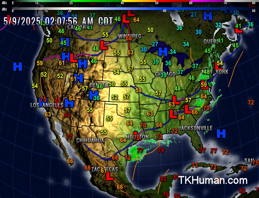 | |||
| US Fronts from NWS | |||
 | |||
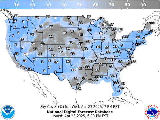
| Sky Cover from the NWS | |||
 | |||
| Current Sat/Rad/Fronts from SSEC.edu | |||
 | |||
| NWS Regional Radar Loop | |||
| Weather Underground Regional Radar Loop | |||
 | |||
| NWS National Radar Loop | |||
| Weather Underground Current US Radar | |||
 | |||
| Current Watches and Warnings | |||
 |
|||
| Regional Satellite | |||
| |||
| Current US Satellite Provided courtesy of UW-Madison SSEC" | |||
 | |||
| Current US Satellite Animation Provided courtesy of NOAA" | |||
 | |||
| Jetstream from WeatherUnderground.com | |||
 | |||
| Tropical Update | |||
 | |||
| Sea Surface Tempeatures from SSEC.wisc.edu | |||
 | |||

© 2026, tkhuman.com |
Weather-Display (10.37S-(b152)) |
Valid
XHTML 1.0 |
Valid CSS
Never base important decisions on this or any weather information obtained from the Internet.
Never base important decisions on this or any weather information obtained from the Internet.